
Topics and Measures for Residents to Make Appropriate Evacuation Decisions in Heavy Rain Disasters
In Japan, the impact from global warning has exacerbated heavy rain disasters due to increases in rainfall amounts during a short period of time. The evacuation of residents is important to minimize human disasters during heavy rains, but mechanisms for enabling appropriate evacuation decisions are still inadequate. In light of such a situation, Nomura Research Institute (NRI) conducted the “Survey Concerning Preparations for and Responses to Flood Damages” of residents of areas that were stricken by Typhoon No. 19 in 2019. We asked Kazuchika Asano and Ryo Nishizaki, who analyzed the results of the survey, what mechanisms are needed for enabling appropriate evacuation decisions in a heavy rain disaster.
Questionnaire of residents of disaster areas, and analysis of mechanisms for appropriate evacuation decisions
As was seen again with the 2020 Kyushu Floods, meteorological disasters have intensified in Japan. To lessen human damage at such times, evacuation of residents is important, but in a Covid-19 environment, to avoid concentration of evacuees in evacuation shelters etc., responses such as dispersed evacuations are also being considered.
In order to ascertain current issues and to create mechanisms for evacuations going forward, NRI conducted the online “Survey Concerning Preparations for and Response to Flood Damage” of residents of areas that were stricken by Typhoon No. 19, which caused tremendous damage in October 2019.
The survey showed that of the 3,190 respondents, 12.2% of the respondents were not aware that advisory levels announcements were issued, and 16.6% of the respondents knew that announcements were issued, but did not ascertain the level. Thus, awareness of advisory level announcements needs to be heightened.
Further, when the behavior of persons who were aware of the advisory level was analyzed, it was found that 76.8% of persons who should have evacuated did not evacuate, and 59.1% of such persons did not even consider evacuating *1 .
The most common reason given for not evacuating was, determination that “staying at home would be safer”, constituting 90% or more of the responses. In light of the fact that such was the response of persons who resided on the second floor or lower in envisioned flood zones on flood hazard maps, it is clear that correct understanding of flood hazard maps is lacking. The second most common answer was, “concerns about the environment of evacuation locations”. Because this survey was conducted in the middle of February, when the impact of Covid-19 was not as great as it is currently, evacuation rates at the current time (July 2020) is expected to further decline.
For an appropriate evacuation, use of appropriate information is important
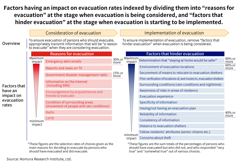
When persons who appropriately evacuated in a situation where they should have evacuated were asked what the deciding factor was for evacuating, the most common responses were “reading the emergency alert email that was sent to my mobile phone” at 30.7%, followed by “seeing the reports and news on TV” at 17.0%, “hearing the government disaster management radio” at 15.9%, and “seeing information on the internet (including SNS)” at 12.5%, meaning information specific to their locations were the top reasons. In contrast, as a reason for evacuating when evacuation was ultimately unnecessary, 37.3% responded “seeing the reports and news on TV”; such a response indicates that they decided to evacuate based on information that was not pinpointed but transmitted to a wide area.
When factors that have an impact on evacuation rates are indexed by dividing them into “reasons for evacuation” at the stage when evacuation is being considered, and “factors that hinder evacuation” at the stage when evacuation is starting to be implemented, as the reasons for evacuation, emergency alert emails and disaster prevention government radio had a large impact on evacuation rates, and as factors that hinder evacuation, the residents’ determination that “staying at home would be safer” and concerns about the environment of the evacuation shelter played a large part.
Preparation of an “Evacuation Rate Improvement Checklist” for local governments to optimize evacuation activities
Based on indexes of “reasons for evacuation” and “factors that hinder evacuation” that have impact on evacuation rates, NRI has been preparing an Evacuation Rate Improvement Checklist *2 for local governments from the two perspectives of “appealing to residents” and “rescue and assistance preparation”.
Restraining residents from making their own determination that “staying at home would be safer” would have the most impact on “appealing to residents”; countermeasures would involve devising a way to convey the dangers of the disaster in a manner that can be easily understood, improving in advance their awareness of the potential for flooding in their residences, and extinguishing normality biases at the time of disasters.
On the other hand, for “rescue and assistance preparation”, the preparation of evacuation location environments is important, and thorough and well-known privacy measures and infection control measures, capacity improvements for area populations, and utilization of existing facilities as evacuation shelters through public-private partnerships etc. will be required. With respect to the area specificity of information, in addition to preparations for provision of specific information using emergency alert emails and area emails, it will be necessary to build mechanisms to provide information that correspond to individual location attributes.
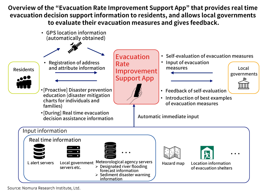
Proposal of an “Evacuation Rate Improvement Support App” to optimize evacuations
Measures that local governments should take to optimize evacuation activities can be divided as follow: as proactive measures, to educate and raise awareness regarding disaster prevention based on an evaluation of each individual’s and each family’s disaster risks; as solutions at the time of advisory level announcements, to develop and deploy realistic real time information communication systems, and develop and deploy mechanisms to enable appropriate action taking into account individual situations.
As a method to assist with the resolution of such issues, the development of an “Evacuation Rate Improvement Support App” has been proposed. Such an app can be utilized by both residents and local governments, and by residents registering their addresses and attributes, disaster prevention education can be carried out by providing disaster mitigation charts for individuals and families before disasters, and by providing real time evacuation decision assistant information based on GPS location information etc. during advisory level announcements.
For local governments, based on the Evacuation Rate Improvement Checklist, the governments will evaluate their evacuation measures, and feedback will be provided. Further, local governments will enter details of their preparations for evacuation measures, and lateral development of best practices among local governments will be supported. For residents, in addition to provision of flood hazard maps and other hazard information, local government information regarding the state of implementation of measures will be provided so they can accurately assess disaster risks in their area of residence.
This is a mechanism that assists appropriate evacuation, by automatically entering in real time designated river flooding forecast information and sediment disaster warning information of L alert servers, local government servers, and meteorological agency servers as input information, incorporating in advance hazard maps and location information of evacuation shelters, and providing such information to residents.
At this current stage, although it has not yet materialized, going forward, in light of field verification tests etc., we would like to continue to develop and utilize the app to assist with optimal dispersed evacuations in a Covid-19 environment.
-
*1
Conditions for residents to determine evacuation: That their residence is “a single-family detached house or a unit that is on the second floor or lower in an apartment building” in “an envisioned flood zone in a flood hazard map”, and during Typhoon No. 19, “the advisory level was understood to be four or higher”, or “the advisory level was understood to be three or higher, with elderly persons residing”.
-
*2
“Evacuation Rate Improvement Checklist”: List of factors that have an impact on evacuation rates that are divided by size into the three stages of “high”, “medium” and “low”, for the purposes of considering and evaluation implementation status of evacuation measures.
Profile
-
Kazuchika Asano
-
Ryo Nishizaki
* Organization names and job titles may differ from the current version.